The cosmos is vast and filled with innumerable stars, many of which are orbited by planets. The question of whether life exists on these distant worlds has captivated humanity for centuries. Today, scientists are actively searching for signs of life on other planets, using a combination of space telescopes, rovers, and sophisticated instruments.
The journey to discover life beyond our planet and dimension is not just a scientific endeavor but also a philosophical one. It asks us to redefine our place in the universe and to expand our imagination to the furthest reaches of possibility.
In conclusion, the search for life on other planets and the exploration of interdimensional life are at the forefront of modern science. While we have yet to find definitive proof of either, the pursuit continues to inspire and challenge our understanding of the universe and our place within it. As we look to the stars and beyond, we remain hopeful that one day we may find that we are not alone.
In the vast expanse of the cosmos, humanity has long pondered the existence of extraterrestrial life and unidentified flying objects (UFOs), now more formally known as unidentified anomalous phenomena (UAPs). The intrigue surrounding these mysterious sightings has been matched only by the skepticism and secrecy often associated with governmental handling of such information. This article delves into the documented instances of potential concealment by the U.S. government, shedding light on the intricate dance between transparency and secrecy.
Adding to the controversy, whistleblowers have accused the U.S. government of hiding alien bodies3. These claims, while sensational, have yet to be substantiated with concrete evidence, leaving the public to wonder about the veracity of such assertions.
The intersection of UFOs, UAPs, and government secrecy is a complex web of intrigue and mystery. While documented examples of concealment exist, the full extent of the government’s knowledge and its reasons for secrecy remain shrouded in ambiguity. As society continues to seek answers, the balance between national security and the public’s curiosity hangs in a delicate balance.
NASA’s Orbiting Carbon Observatory (OCO-2) satellite can make precise measurements of global atmospheric carbon dioxide (CO2) from space. (NASA/JPL-Caltech)
The central objective of the Paris Agreement is to limit Earth’s warming to well below 2 C above pre-industrial levels, but preferably 1.5 C.
This challenging task will require policies and tools to enable every sector of society to drastically reduce greenhouse gas (GHG) emissions to eventually reach net-zero.
Enacting the most effective and efficient strategies to reduce emissions starts with knowing in detail where, when and how much of these greenhouse gases we are emitting, followed by implementing emission reduction policies and tracking our progress.
Is it possible to track carbon dioxide (CO2) emissions and emission reductions from space? New research from my group shows that it is.
Why CO2 matters
CO2 is the primary greenhouse gas driving climate change. Burning fossil fuels for electricity generation, heating buildings, industry and transportation has elevated the CO2 in our atmosphere well beyond natural levels.
Currently, CO2 emission reporting is mainly done by accounting for the mass of fossil fuels purchased and used, then calculating the expected emissions — not actual atmospheric CO2 measurements. The finer details about exactly when and where the emissions occurred are often not available, but more transparent monitoring of CO2 emissions could help track the effectiveness of policies to reduce emissions.
Today GPS satellites help us to get around, meteorological satellites track weather systems and communication satellites relay TV, internet and telephone signals. It is time we use satellites to help tackle the biggest challenge that humanity has ever faced — climate change.
Satellites can observe the entire planet. Those that measure CO2 in the lower atmosphere near Earth’s surface (where CO2 emissions and CO2 uptake by plants happens) first began making measurements in 2002. Since then, they have been getting better and better at doing it, but there have been setbacks along the way.
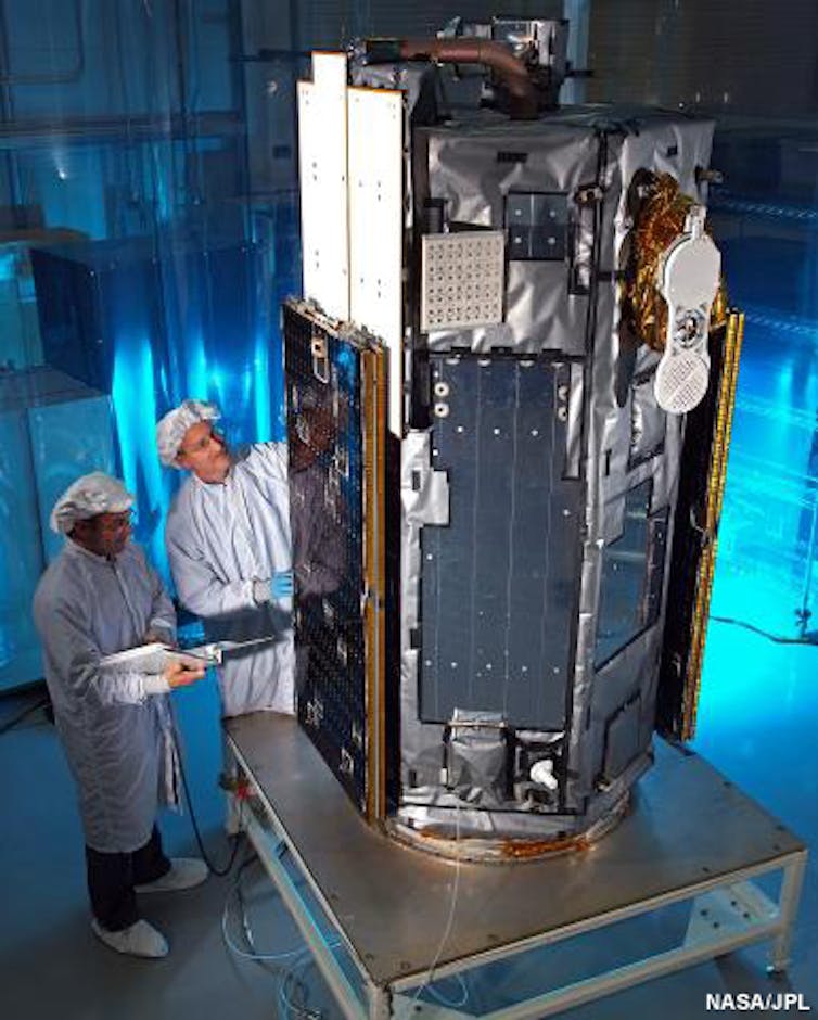
About a decade of effort by NASA went into developing the Orbiting Carbon Observatory (OCO) satellite to make precise measurements of atmospheric CO2 across the Earth.
NASA developed the Orbiting Carbon Observatory satellite to make precise measurements of atmospheric CO2 across the Earth. (NASA/JPL), Author provided
In 2009, OCO was lost due to a launch problem. After sustained advocacy for a rebuild of this important climate mission, NASA secured new funding to launch the OCO-2 satellite in 2014 and OCO-3 to the International Space Station in 2019.
The OCO missions were designed to improve our understanding of vegetation’s CO2 absorption, also known as the land carbon sink. But what about fossil fuel CO2 emissions?
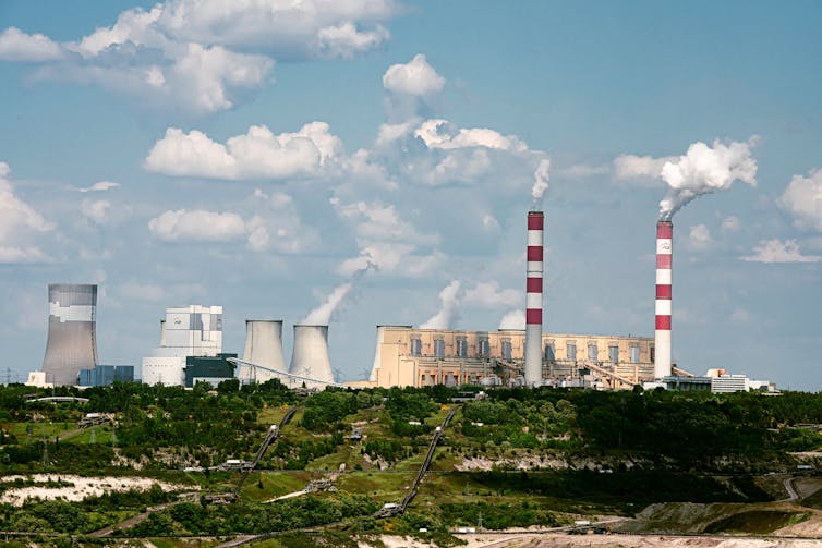
OCO-3 is very similar to OCO-2, but has an additional pointing mirror that enables it to better map CO2 around targets of interest like the Bełchatów Power Station in Poland, Europe’s largest fossil fuel burning power plant and CO2 source.
Bełchatów Power Station, Europe’s largest fossil fuel burning power plant. (Shutterstock)
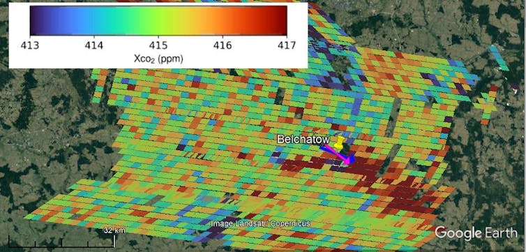
With ten clear views of CO2 emission plumes from Bełchatów imaged by OCO-2 and OCO-3 from 2017-2022 analyzed in our new study, we were able to determine emissions on those days.
European power plants report hourly power generation but only annual CO2 emissions. Power generation fluctuates with electricity demand and generating unit shutdowns (for maintenance or decommissioning) and CO2 emissions are expected to exhibit proportional fluctuations.
We confirmed this using OCO-2 and OCO-3 in our recent paper, which showed that satellite observations can track changes in facility-level CO2 emissions. This means that satellites can be used to verify (or refute) reported CO2 emission reductions that result from climate change mitigation — like mandated efficiency improvements, carbon capture and storage technology, etc.
A plume of high CO2 resulting from coal burning is evident down wind from the Bełchatów Power Station in OCO-3 observations. (Ray Nassar), Author provided
Emissions monitoring for the Paris Agreement
Our approach can be applied to more power plants or modified for CO2 emissions from cities or countries with OCO-2 and OCO-3. We can also try integrating the satellite observations with CO2 monitoring from the ground or aircraft.
While we are already working on this, advances will only be incremental until the launch of the European Commission-funded Copernicus Anthropogenic CO2 Monitoring Mission or “CO2M”. CO2M is comprised of two satellites, aiming to launch in late 2025.
Hopefully, with new, more detailed and transparent tracking of human-caused greenhouse gas emissions to assess and guide us toward the most effective policies, society can achieve the emission reductions needed to reach net-zero in time.
Ray Nassar, Research Scientist at Environment and Climate Change Canada (ECCC), Adjunct Professor in Atmospheric Physics, University of Toronto
Researchers discovered five new species of black corals, including this Hexapathes bikofskii growing out of a nautilus shell more than 2,500 feet (760 meters) below the surface. Jeremy Horowitz, CC BY-NC
The Research Brief is a short take about interesting academic work.
The big idea
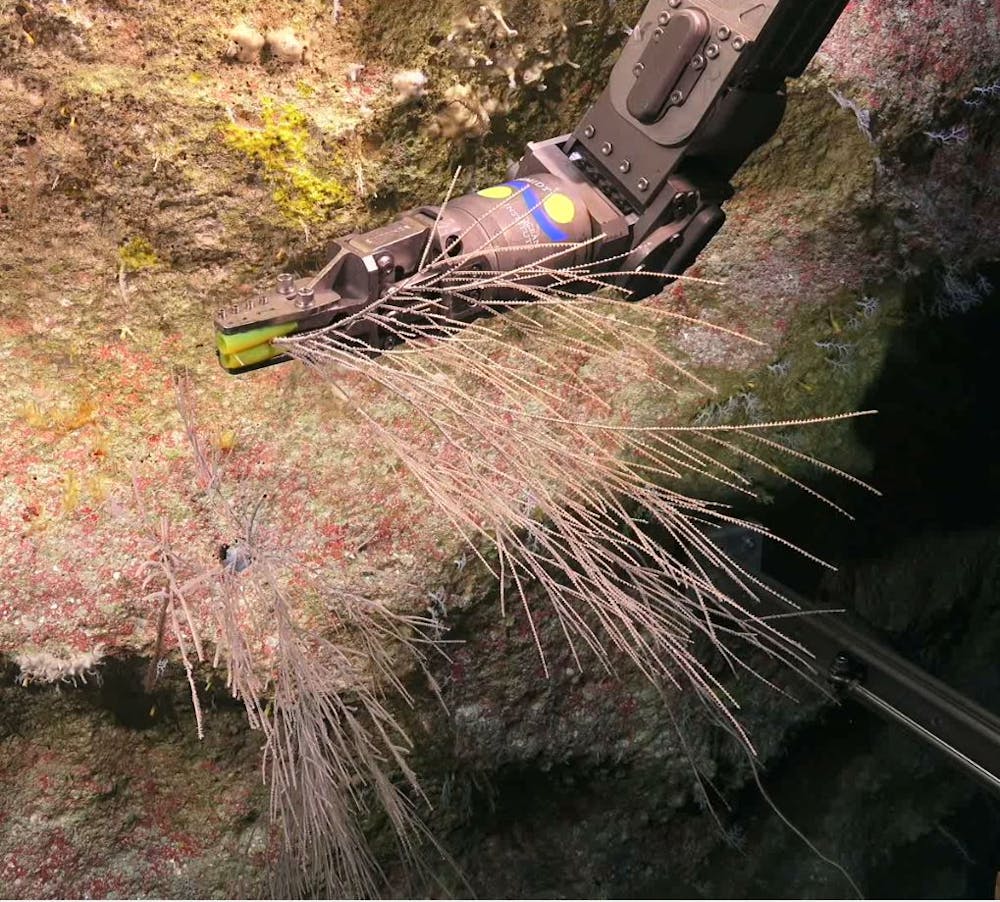
Using a remote-controlled submarine, my colleagues and Idiscovered five new species of black corals living as deep as 2,500 feet (760 meters) below the surface in the Great Barrier Reef and Coral Sea off the coast of Australia.
In 2019 and 2020, I and a team of Australian scientists used the Schmidt Ocean Institute’s remotely operated vehicle – a submarine named SuBastian – to explore the Great Barrier Reef and Coral Sea. Our goal was to collect samples of coral species living in waters from 130 feet to 6,000 feet (40 meters to 1,800 meters) deep. In the past, corals from the deep parts of this region were collected using dredging and trawling methods that would often destroy the corals.
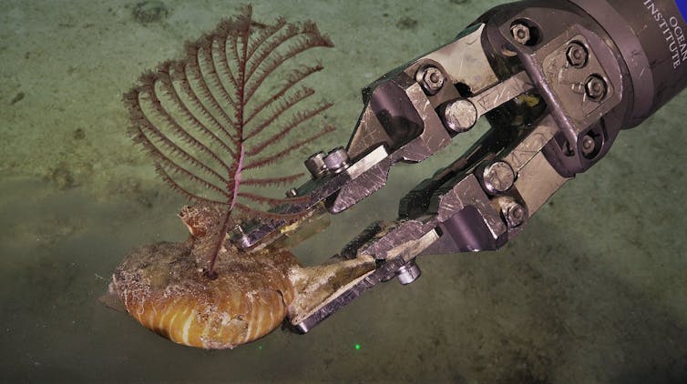
Our two expeditions were the first to send a robot down to these particular deep-water ecosystems, allowing our team to actually see and safely collect deep sea corals in their natural habitats. Over the course of 31 dives, my colleagues and I collected 60 black coral specimens. We would carefully remove the corals from the sandy floor or coral wall using the rover’s robotic claws, place the corals in a pressurized, temperature-controlled storage box and then bring them up to the surface. We would then examine the physical features of the corals and sequence their DNA.
Researchers used the robotic arm of their rover to collect over 100 samples of rare corals and brought them up to the surface for further study. Jeremy Horowitz, CC BY-ND
Why it matters
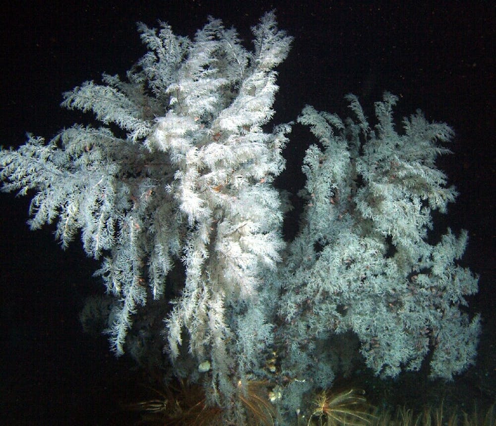
Similarly to shallow-water corals that build colorful reefs full of fish, black corals act as important habitats where fish and invertebrates feed and hide from predators in what is otherwise a mostly barren sea floor. For example, a single black coral colony researchers collected in 2005 off the coast of California was home to 2,554 individual invertebrates.
Recent research has begun to paint a picture of a deep sea that contains far more species than biologists previously thought. Considering there are only 300 known species of black corals in the world, finding five new species in one general location was very surprising and exciting for our team. Many black corals are threatened by illegal harvesting for jewelry. In order to pursue smart conservation of these fascinating and hard-to-reach habitats, it is important for researchers to know what species live at these depths and the geographic ranges of individual species.
Black corals don’t form large reefs like shallow corals, but individuals can get quite large – like this Antipathes dendrochristos found off the coast of California – and act as habitat for thousands of other organisms. Mark Amend/NOAA via Wikimedia Commons
What still isn’t known
Every time scientists explore the deep sea, they discover new species. Simply exploring more is the best thing researchers can do to fill in knowledge gaps about what species live there and how they are distributed.
Because so few specimens of deep-sea black corals have been collected, and so many undiscovered species are likely still out there, there is also a lot to learn about the evolutionary tree of corals. The more species that biologists discover, the better we will be able to understand their evolutionary history – including how they have survived at least four mass extinction events.
What’s next
The next step for my colleagues and me is to continue to explore the ocean’s seafloor. Researchers have yet to collect DNA from most of the known species of black corals. In future expeditions, my colleagues and I plan to return to other deep reefs in the Great Barrier Reef and Coral Sea to continue to learn more about and better protect these habitats.


